Guillermo,
this might be a start:
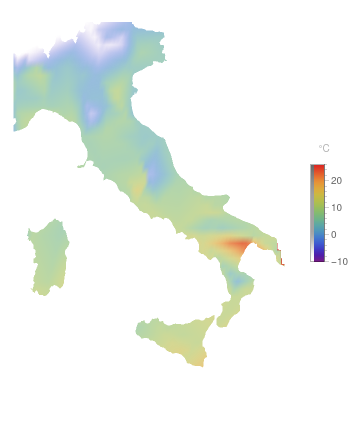
stations = GeoEntities[Entity["Country", "Italy"], "WeatherStation"];
(* the data: *)
stationsData0 = Quiet[{#, #["Position"], AirTemperatureData[#]} & /@ stations];
(* data without "Missing[]" *)
stationsData = DeleteMissing[stationsData, 1, Infinity];

GeoDensityPlot[stationsData[[All, 2]] -> stationsData[[All, 3]],
 ColorFunction -> "Rainbow", RegionFunction -> Entity["Country", "Italy"], GeoBackground -> None,
 PlotLegends -> Automatic]
I guess that SpatialEstimate does not digest GeoPosition data; I would use cartesian coordinates (like UTM, i.e. their numeric values).
Addendum - @Rohit Namjoshi: I saw your post too late, sorry! Interestingly this works with units:
sf = SpatialEstimate[Identity @@@ stationsData1[[All, 2]] -> stationsData1[[All, 3]]]
but then the number which is given back seems to be the temperature in Kelvin:
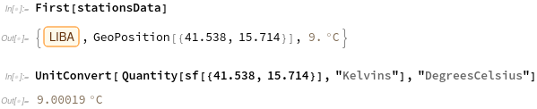
Really strange!


