Objective
As the planet warms, ice melts and oceans expand, resulting in sea level rise. This process threatens many coastal cities, and locations such as Kent Island in Maryland and the Maldives in the Pacific ocean are already considering relocation.
This project builds off of a previous demonstration to model sea level rise in any location on earth in a more user-friendly manner. The user can view any region and manipulate the sea level; additionally, political boundaries have been added to better visualize the loss of land. Users can also input an address, and a map with multiple zoom levels will be displayed around this address. Finally, an option showing the world if all ice melted has been added.
Core function
Data for a rising ocean was simulated using the code from this wolfram demonstration, which replaces the lowest z values, or height, with a new sea level:
{elev1, geodata, level},
geodata =
 GeoElevationData[location, Automatic, "GeoPosition",
  GeoZoomLevel -> Automatic];
elev1 = QuantityMagnitude[
  GeoElevationData[location, GeoZoomLevel -> Automatic]];
level = Min[elev1];

elev1 /. z_Real /; z < seaLevelManipulate -> level
Since code returns new simulated elevation data, it can be plotted in a relief plot. With some formatting, this manipulate can be turned into a base function that returns a relief plot with a new sea level for any location on earth, given a location and sea level. For example, it can be displayed with a manipulatable sea level, along with a political boundary for reference: 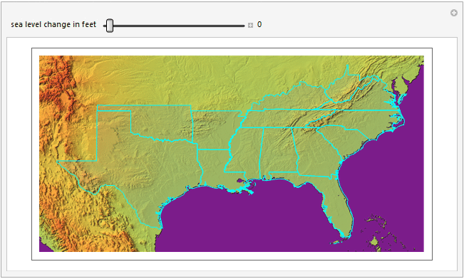
Addresses and zoom levels
Building off of the newly created base function, addresses were implemented to allow the user to better visualize the effect on a specific area. Given a full address, the function selects the different administrative divisions of a given location to make "zoom levels". This allows the user to explore their address in progressively more detail to get a more thorough perspective. A menu was also included to show the theoretical maximum sea level rise, to again give the user a better perspective on this issue. Below is an example of the full manipulate in a GIF, the function can be found in the notebook below. 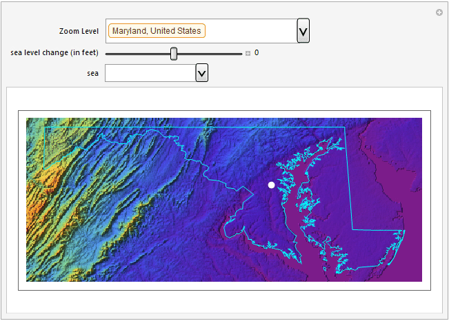
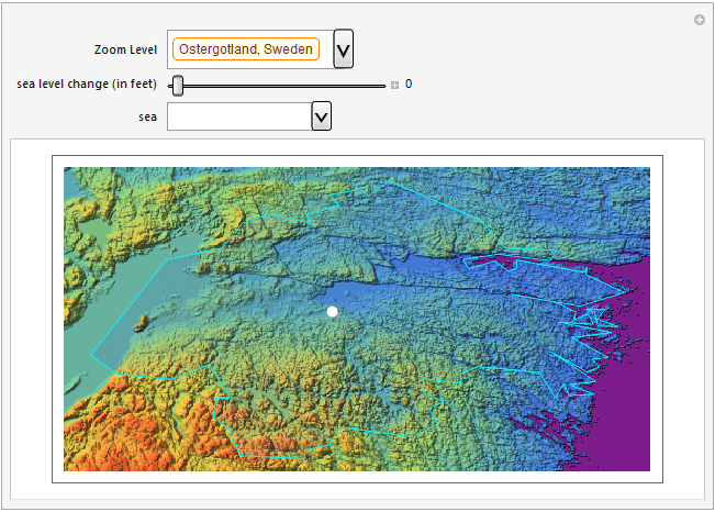
Here is another example: This shows sea level rise at Wolfram's Sweden offices.
Conclusions and future work
These plots and GIFs demonstrate that even a small change in sea level can wipe out a large amount of land, such as the states of Florida and Maryland. Additionally, the predicted maximum rise of 216 feet could have strong effects in various regions of the world and has the potential to wipe out many cities and locations without proper preparation for sea level rise.
In order to make this function more accessible, the functions could be put on a website to allow for anyone to explore sea level rise. This was attempted, but difficulties arose that will need to be revisited. Another possible feature to revisit would be to return the land lost for any given area, to give more perspective on how a small global change could potentially have a large impact. Finally, the function could consider land that is currently under sea level, such as the Netherlands, more accurately portray how they are filled. Different techniques of elevation data analysis and image processing were explored, but the techniques would need to be improved to recognize geological depressions from oceans and to generate proper topological maps.
Attached below is a notebook with the function that implements sea level rise with an address, along with an additional animation.
 Attachments:


