Message Boards Message Boards

Apply four color theorem to the map of Florida?

I'm attempting to apply the Four Color Theorem to a map of Florida and I'm following an example available among the standard collection of examples located at: ref/GeoGraphics; "Neat Examples" (provided by my Mathematica software). Unfortunately; the following:

EntityProperty["AdministrativeDivision", "BorderingCounties"] 

doesn't work when I evaluate it using my Mathematica software. I found an alternative way to get around this difficulty and I can apply the four color theorem to subareas of the map of Florida but, the same code that I use for the subareas will not work for the whole state. I have built the attached Mathematica notebook explaining my problem in detail. Thank you for your help!

Attachments:
8 Replies

Here's a very compact solution using IGraph/M's IGVertexColoring function.

counties = EntityList@EntityClass["AdministrativeDivision", "USCountiesFlorida"];

borderingQ[c1_, c2_] := MemberQ[c1["BorderingCounties"], c2]

graph = RelationGraph[borderingQ, counties];

GeoGraphics@
 MapThread[{GeoStyling[#2], Polygon[#1]} &, {counties, ColorData[97] /@ IGVertexColoring[graph]}]

Mathematica graphics

?IGVertexColoring

IGVertexColoring[graph] returns a vertex colouring of graph.

Currently this function does not guarantee a minimum colouring, but it does well here. You can see the fifth colour (purple) around the quintipoint in the South East.

POSTED BY: Szabolcs Horvát
Posted 7 years ago

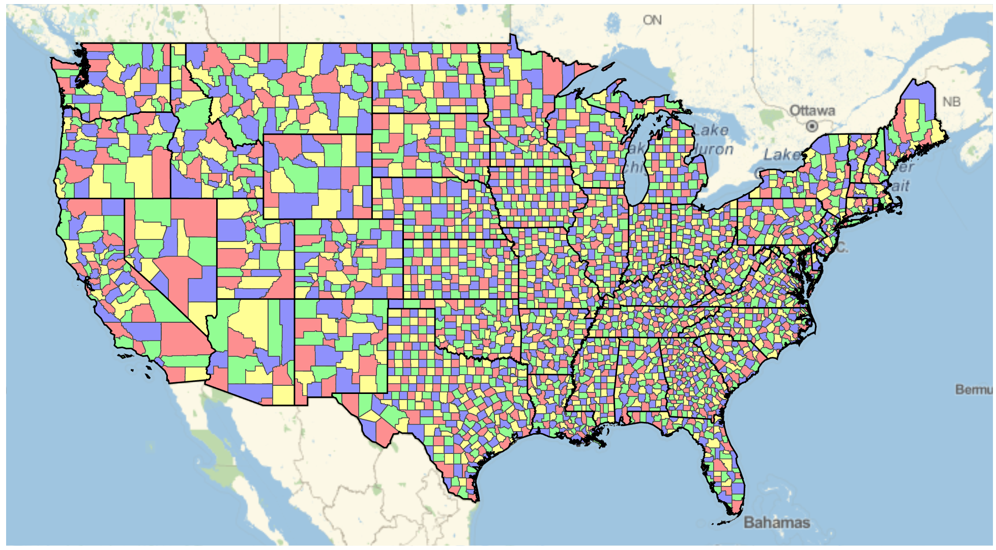
There's a 'quintipoint' in Florida, which breaks the ability to have a 4 color map.

See here for more info: http://community.wolfram.com/groups/-/m/t/932548.

About a year ago I did this for all US counties: enter image description here

Here's the code I used. Note how I manually tweaked the quintipoint.

states = DeleteCases[
   Entity["Country", "UnitedStates"][
    EntityProperty["Country", "AdministrativeDivisions"]], 
   s_ /; ! FreeQ[s, "Alaska" | "DistrictOfColumbia" | "Hawaii"]];

$triple = 
  Entity["AdministrativeDivision", {"PalmBeachCounty" | 
     "GladesCounty" | "OkeechobeeCounty", "Florida", "UnitedStates"}];

counties = 
  Join @@ (EntityList[
       EntityClass["AdministrativeDivision", 
        "USCounties" <> CanonicalName[#][[1]]]] & /@ states);
nassoc = EntityValue[counties, "BorderingCounties", 
   "EntityAssociation"];
neighbors = {#, 
     Intersection[nassoc[#] /. _Missing -> {}, counties]} & /@ 
   counties;
neighbors = 
  neighbors /. {c : $triple, n_} :> {c, DeleteCases[n, $triple]};
toColor[tf_] := <|{False, False} -> Red, {False, True} -> 
    Blue, {True, False} -> Green, {True, True} -> Yellow|>[tf]
eqs = And @@ (Flatten[
     Function[{c, n}, 
       BooleanConvert[Xor[x[c], x[#]] || Xor[y[c], y[#]], "CNF"] & /@ 
        n] @@@ neighbors]);
MaxMemoryUsed[
  solution = 
   Join[First[
     FindInstance[eqs, Union[Cases[eqs, _x | _y, \[Infinity]]], 
      Booleans]],
    Flatten[{x[#] -> True, y[#] -> True} & /@ 
      Flatten[Cases[neighbors, {_, {}}]]]]] // AbsoluteTiming
coloring = (#[[1, 1, 1]] -> Lighter@Lighter@toColor[Last /@ #]) & /@ 
    Partition[SortBy[solution , #[[1, 1]] &], 2]; // Quiet

(* {206.017, 20929584} *)

GeoGraphics[{
  {EdgeForm[{AbsoluteThickness[0.1], 
     GrayLevel[0.3]}], {GeoStyling[#2], Polygon[#1]} & @@@ coloring},
  {EdgeForm[{AbsoluteThickness[1.5], Black}], FaceForm[], 
   Polygon[EntityList[
     EntityClass["AdministrativeDivision", "ContinentalUSStates"]]]}
  }, GeoProjection -> "Mercator"]
POSTED BY: Greg Hurst
Posted 7 years ago

I am going to assume that in your solution you want a nested list of string values that represent the Counties with which you are interested. In that case, you will need to apply the EntityValue function to a valid Entity Data Types. However, you will first need to obtain an Entity Class from your strings that represent the Entity Types you seek.

xx = EntityValue[
   EntityClass["AdministrativeDivision", "USCountiesFlorida"], 
   "BorderingCounties"];

EntityValue[#, "Name"] & /@ xx
POSTED BY: Joel Gilly

@Joel Gilly Thank you for responding to my query. I have no trouble getting the list of counties as you described. The trouble occurs when attempting to color the counties as described in another Mathematica notebook located at: http://community.wolfram.com/groups/-/m/t/1097057 Thank you for your help!

Did you already try this?

Find a Four-Coloring of a Map of Europe

POSTED BY: Aeyoss Antelope

@Aeyoss Antelope: Yes Aeyoss; that is indeed the example that I'm emulating; with counties in Florida instead of countries in Europe. Thank you.

Thanks for this! I forgot about the quintipoint, making this into a Google Corp interview question...

Interviewer: How would you make a four-color map of the counties of the state of Florida?

Applicant: It is not possible because of the quintipoint! Hahaha

POSTED BY: Aeyoss Antelope

Thank you Chris Hurst for your discussion about quintipoints and your incredible code to build the map of the USA. I wish I had read your posts before learning about quintipoints the hard way! And thank you Aeyoss Antelope for your wonderful sense of humor! Google (and other corporate) interviewees; beware about your "IQ" ; i.e., beware about the "Infamous Quintipoint" question! LOL.

Reply to this discussion
Community posts can be styled and formatted using the Markdown syntax.
Reply Preview
Attachments
Remove
or Discard

Group Abstract Group Abstract