Message Boards Message Boards

Do something similar using my own coordinates

Posted 9 years ago

In these days of rest , I was talking with sometbody people dedicated to different things to mine, but all use the computer every day , something that interested me, I want to share, is basically, if you can do the following in Mathematica . given the latitude and longuitud of a place on earth , obtained with google earth , could you get something like that shown in Mathematica documentation ? where Mount Everest is used , explain below what I mean .

I have the following coordinates: Latitude 19 °34'14''N and of longitude 98 ° 47'12''W and I would like to get something like what they do in the Mathematica documentation ,I put the code here

imageofdocumentacion

is there any way to do the same using the coordinates that I have ?, if anyone has any idea how to do that I would appreciate help , because this problem is the first time I am trying to solve something like this. Thanks in advance

POSTED BY: Luis Ledesma
4 Replies
Posted 9 years ago

Marco thank you very much for your help and patience to help me find the solution to the error Mathematica threw me everything and works wonders.

Greetings Luis .

POSTED BY: Luis Ledesma
Posted 9 years ago

Hi mark, thank you very much for your help with this problem, the solution that your i've works, but I have problems when you run the following lines,i don't know why Mathematica i drew attention to an error, please see the image

error throw mathematica

the rest works really well, i currently i am using Mathematica 10.0 and do not understand why the error, many thanks again.

POSTED BY: Luis Ledesma

Hi Luis,

it works fine on my system (MMA10.3, OSX10.11). It is strange that yo have problems at that point, given that the same thing worked a couple of lines earlier where you get "data". Quantity was introduced in MMA9 and updated in 10.0 so that should not be a problem. Having said that, GeoBoundingBox seems to have been updated in 10.1 so you would not have that update.

GeoDisk seems to work in "data". Could you please try

img = Image[
  GeoGraphics[{GeoStyling[Directive[Opacity[0]], 
     GeoDisk[GeoPosition[{35227/1800, -7409/75}], 
      Quantity[10, "Miles"]]]}]]

Cheers,

Marco

POSTED BY: Marco Thiel

Hi Luis,

I guess that in principle this works:

data = GeoElevationData[GeoDisk[Here, Quantity[10, "Miles"]]];
ListPlot3D[data, MeshFunctions -> {#3 &}, Mesh -> 40]

It tries to estimate your GPS coordinates from our IP address. Sometimes that doesn't work quite well. If you know your geoposition you can use an inline semantic input like so:

enter image description here

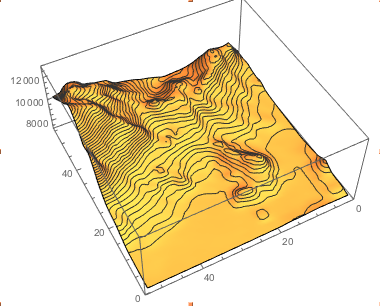
For your position this is:

data = GeoElevationData[GeoDisk[GeoPosition[{35227/1800, -7409/75}], Quantity[10, "Miles"]]];
ListPlot3D[data, MeshFunctions -> {#3 &}, Mesh -> 40]

enter image description here

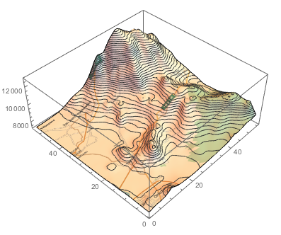
You can make this look a bit nicer like so:

img = Image[GeoGraphics[GeoBoundingBox[GeoPosition[{35227/1800, -7409/75}], Quantity[10, "Miles"]]]]
ListPlot3D[data, MeshFunctions -> {#3 &}, Mesh -> 40, PlotStyle -> Directive[Texture[img]]]

enter image description here

Cheers,

Marco

POSTED BY: Marco Thiel
Reply to this discussion
Community posts can be styled and formatted using the Markdown syntax.
Reply Preview
Attachments
Remove
or Discard

Group Abstract Group Abstract